


chapelle ste anne

logette
User
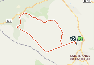

Length
9.6 km

Max alt
434 m

Uphill gradient
309 m
Km-Effort
13.7 km

Min alt
186 m

Downhill gradient
311 m
Boucle
Yes
Creation date :
2021-06-06 09:29:11.043
Updated on :
2021-06-06 09:29:34.114
3h07
Difficulty : Easy

FREE GPS app for hiking
 SityTrail
IGN / Geographical institutes
SityTrail Plus
The world is yours!
About
Trail On foot of 9.6 km to be discovered at Provence-Alpes-Côte d'Azur, Var, Le Castellet. This trail is proposed by logette.
Positioning
Country:
France
Region :
Provence-Alpes-Côte d'Azur
Department/Province :
Var
Municipality :
Le Castellet
Location:
Unknown
Start:(Dec)
Start:(UTM)
724290 ; 4790333 (31T) N.
Comments